Rising river levels across Yorkshire prompts Tadcaster Bridge closure and more flood warnings for York

Storm Jocelyn and Storm Isha may be behind us, but recent heavy rain has raised river levels across Yorkshire.
Tadcaster Bridge is closed today (Jan 30), due to rising fast-flowing levels of the River Wharfe that could pose a potential risk to the structural integrity of the bridge and create hazardous conditions for drivers and pedestrians, North Yorkshire Council confirmed.
Advertisement
Hide AdAdvertisement
Hide AdThe bridge is closed when water reaches approximately 2.4m as a “proactive measure!” aimed at preventing any potential accidents or damage to the structure.
“The safety of all road users is paramount and any closures of Tadcaster Bridge are only done so when absolutely necessary,” the council said.
This road is not the only one closed due to adverse weather conditions, several across the north of the county are also impassable, including:
- Hamhall Lane, Scruton
- C28 Melsonby to Aldbrough St John
- U1075 Moor Lane, Newsham
- C1 Scurragh House Lane
-
Great Smeaton To Hornby
-
Yafforth Road between Chantry Road, Romanby and Castle HIlls Farm
-
Mounstrall Lane
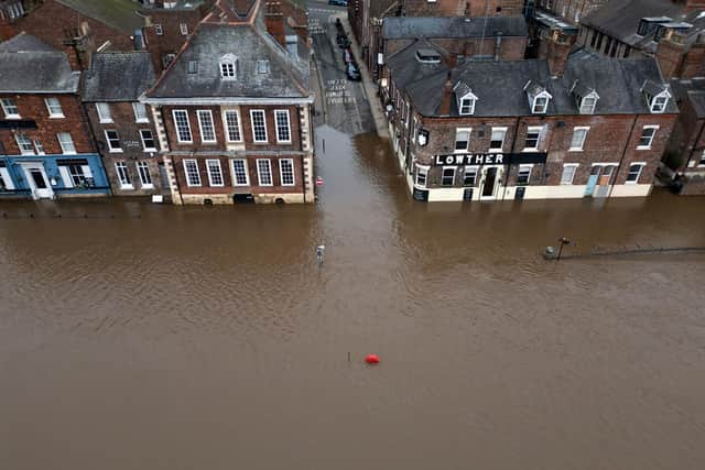
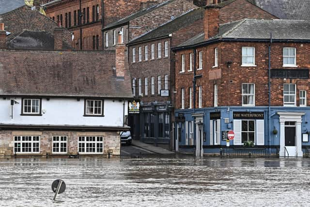
Six flood warnings are also in place across Yorkshire – including two that threaten York, just a week after the banks of the River Ouse burst flooding parts of the city.

Advertisement
Hide AdAdvertisement
Hide AdFlooding is forecast to affect locations near the River Ouse, with low-lying land expected to be most affected, particularly around properties on King's Staith in York and riverside areas through York, from Lendall Bridge to Millennium Bridge.
Flooding is also expected at properties along Queen's Staith, on South Esplanade, Friars Terrace and Tower Place, St. George's Field carpark and Rowntree Park.
Flood gates through the city are closed and the Foss barrier is currently in operation to tackle the rising river levels.
Locations near the River Ouse, with low-lying land are expected to also affected, particularly around Naburn Lock Buildings and Lock Cottages.
Advertisement
Hide AdAdvertisement
Hide AdA warning remains in placen the upper River Hull catchment remain high following recent rainfall and high groundwater levels.
Areas most at risk include the River Hull and its tributaries at Frodingham, Hempholme, Wilfholme and Burshill, including Roam Drain.
River levels are high and forecast to rise further on the River Ure due to heavy and persistent rainfall, with flooding is expected to affect Boroughbridge Camping and Caravanning Site.
A flood warning means you need to “act now” as flooding is expected. People with this warning should:
- move vehicles to higher ground if it’s safe to do so
- move family and pets to safety
- move important items upstairs or to a safe place in your property, starting with cherished items and valuables, then furniture and furnishings
- turn off gas, electricity and water supplies if it’s safe to do so; never touch an electrical switch if you’re standing in water
- if you have property protection products such as flood barriers, or air brick covers, use them now
- keep track of the latest flood risk sit
Advertisement
Hide AdAdvertisement
Hide Ad22 flood alerts – where flooding is possible – are also in place across Yorkshire:
- Gypsey Race and the Wolds
- Lower Dunsforth Access
- Lower River Derwent
- Lower River Nidd catchment
- Lower River Tees and estuarine tributaries
- Lower River Ure
- Lower River Wharfe
- Middle River Aire catchment
- Middle River Nidd catchment
- Osbaldwick Beck and Tanghall Beck
- River Foss
- River Foulness and Market Weighton catchment
- River Hull Central catchment
- River Rye catchment
- River Seven catchment
- River Wiske and other tributaries of the River Swale
- Tidal River Ouse from Naburn Lock to Selby
- Upper River Aire catchment
- Upper River Derwent
- Upper River Hull catchment
- Upper River Ouse
- Upper River Wharfe
Comment Guidelines
National World encourages reader discussion on our stories. User feedback, insights and back-and-forth exchanges add a rich layer of context to reporting. Please review our Community Guidelines before commenting.